Cesium 3D Heritage Map
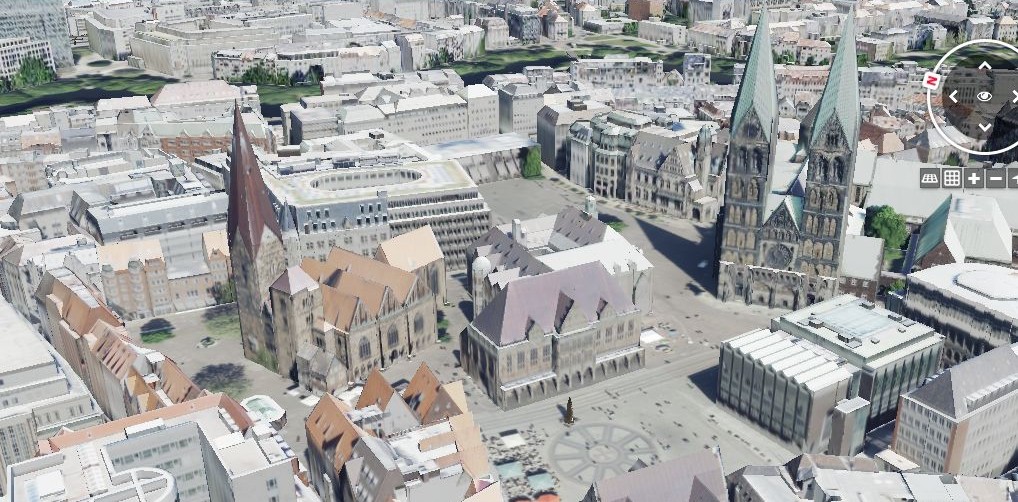
Cesium 3D Heritage Map is an open-source, web-based application built on top of CesiumJS — a powerful JavaScript library for creating high-precision, interactive 3D globes and maps. The platform allows users to explore and visualize cultural heritage assets such as 3D models, photos, historical information, and geospatial data from sources like Wikipedia and OpenStreetMap.
With features like interactive 3D visualization, external model integration, photo and text layers, and even story mapping, the project aims to preserve and present heritage in an engaging digital format that can be accessed by anyone, anywhere.
Open to Collaboration
The project is fully open for contributions. Whether you are a developer, designer, historian, or simply passionate about cultural heritage, you can enrich the platform in many ways:
-
Uploading or linking 3D models of heritage sites
-
Adding photographs and descriptive content
-
Creating story maps that narrate the history behind places
-
Improving the interface, features, or performance through code contributions
By being community-driven, Cesium 3D Heritage Map grows stronger with each contribution, combining technology and culture to create a living, evolving digital archive.
Call to Action
Bring Heritage to Life in 3D
Cesium 3D Heritage Map is not just a map—it’s an open invitation to collaborate. Explore heritage sites in 3D, contribute your own models, photos, or stories, and help shape a platform where history meets technology.
Whether you’re an enthusiast, researcher, or developer, your contributions make this digital heritage map richer and more meaningful. Together, we can ensure that cultural heritage is preserved, shared, and experienced by future generations.
